Topographic Analysis
Topographic Analysis - add the third dimension to your SEM
The point electronic BSE Topography system is the only solution that provides live quantitative and calibrated measurement of surface height, with live 3D visualization in Scanning Electron Microscopy.
It helps researchers distinguish variations in height and morphology. This technique is invaluable for characterizing sample surfaces in SEM and FIB-SEM environments.
It's designed for multivendor environments and interfaces seamlessly with standard topography software, including offline analysis and 3D printing file formats.
As a complete detector and scan controller system, the BSE Topography solution can be retrofitted into any microscope with a suitable BSE port.
The system consists of hardware and software.

3D dynamics
Record, measure and animate changes of surface topography - now including high-temperature in-situ experiments.

3D Measurements
Measure height differences, profiles and other geometric features, or verified by integrated 3D calibration.

3D navigation
Explore surface topography in real time and understand your samples better with a dynamic 3D view - live while moving the sample or adjusting magnification.

Correlative 3D microscopy
Acquire and visualize any SEM analog and digital signal as texture on sample height maps - now including EBIC for correlative electrical analysis.

Standard 3D analysis
Leverage captured 3D data with off-line external analysis software tools, such as particle distribution and surface roughness.

Automated 3D workflows
Remotely acquire surface topography and multichannel SEM signals for live analysis and feedback, such as AI-based fracture analysis.

Live and calibrated height measurements
The BSE Topography control software includes live surface height reconstruction from BSE signals, a built-in 3D surface visualization tool and configurable workflows with integrated SE and BSE scan profiles.
Customizable workflow: Fully configurable scan profiles, including live scan or high resolution acquisition
Project setup: Project parameters for save and auto-save, routine workflows and remote control
Detector control: Brightness and contrast with automated signal adjustment, detector insertion and retraction
Automated calibration: Automated determination and correction of lateral and height scales with 3D calibration sample
Automated 3D time series: Automated acquisition of time-series for 3D in-situ microscopy, including live height
Live 2D view of height: At every point on the sample, height is determined from the four simultaneous BSE signals given by the four quadrants of the detector
Live 3D view with texture: 3D visualization of measured topography using height-coded colors or raw SEM signals as texture

Turn-key quantitative BSE for any SEM or FIB-SEM
As a complete detector and scan controller system, the point electronic BSE Topography solution can be retrofitted into any microscope with a suitable BSE port.

3D calibration standard
Spatial calibration sample with reference marks for automated geometrical calibration, ensures correct height scale

BSE detector
4Q segmented BSE detector with calibrated amplifier, including automated signal adjustments and insertion/retraction mechanism

DISS6 Scan Controller
Calibrated multi-channel imaging system for simultaneous acquisition of BSE and SEM signals

DISS6 APP with topography plugin, and microShape app
Reconstruction and live visualization of quantitative surface maps and SEM signals, with integrated 3D calibration

3D calibration standards
- Marker based 3D structures for X, Y, Z calibration
- Reference information traceable to Physikalisch-Technische Bundesanstalt (PTB)
- With reference marks for automated calibration

Premium BSE detector
- Four quadrant Si sensor for advanced BSE work
- In-situ preamplification for optimum efficiency and speed
- Low-kV sensors

DISS6 SEM Scan Controller
- High-performance calibrated electronics for image acquisition
- Integrated and automated amplification of BSE signals
- With truly simultaneous acquisition of all BSE signals

DISS6 acquisition with topography plugin
- Software for live BSE topography reconstruction and visualisation
- Quantitative image acquisition and detector control
- Height and texture save to standard file formats
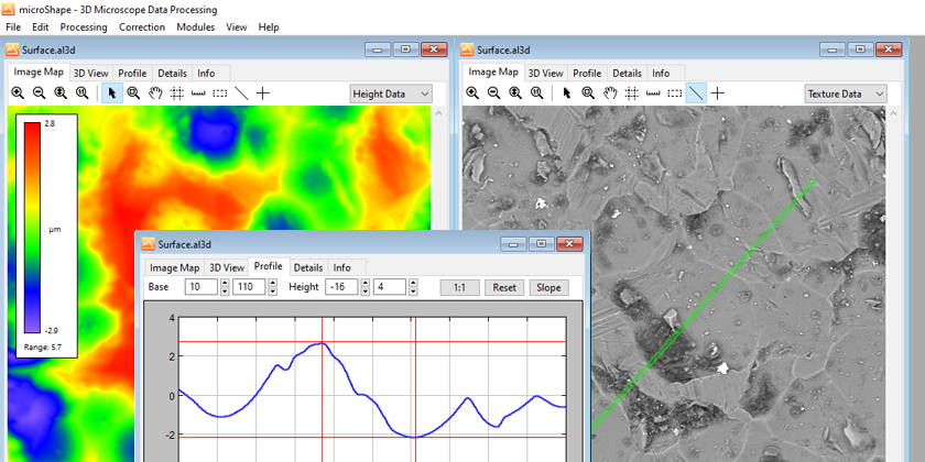
microShape
- Offline 3D viewer of BSE topography data
- Measurement of line profiles, heights, distances and angles in 3D
- 3D data processing including data correction and overlay
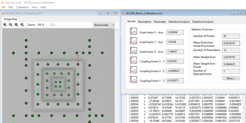
microCal
- Offline 3D calibration and reporting software
- Automated calculation of scales and shearing between all coordinate axes
- Analyses of non-linear scanning deviations
microDIP image processing
- Software for display of quantitative image data
- Inspection of acquisition settings in metadata
- Extraction of quantitative pixel values